
Seeing the Forest and the Leaves: How UAVs Could Change Ecological Mapping
UAVs are reshaping ecological mapping by helping bridge the gap between detailed field surveys and broad-scale remote sensing. This post explores how drones, spectral data, and machine learning can make species-level mapping more practical, repeatable, and useful for real-world land management.
UAV MAPPING
The Trade-off Between Resolution and Extent
Ecological mapping has always involved a trade-off between resolution and extent. At one end, field survey can achieve extraordinary biological resolution. A skilled ecologist working at quadrat or transect scale can identify small understory plants, record fine differences in species composition, recognise diagnostic features, and capture evidence of animals, invertebrates, disease, disturbance, and site condition that may not be visible from above. The detail can be exceptional. The limitation is spatial representation. Quadrat surveys, walkovers, and transects are necessarily selective. They sample a site rather than exhaustively describe it. That is not a weakness in itself; it is how most ecological survey has to work. But as the area of interest grows, or as the vegetation becomes more mixed and variable, the gap between what has been directly observed and what is inferred across the wider site becomes increasingly important.
Broad habitat mapping manages this trade-off by simplifying ecological variation into interpretable classes. Systems such as NVC, Phase 1, and UKHab are useful precisely because they reduce complexity into a structure that can be surveyed, mapped, and communicated. For many purposes, that is appropriate. But there are many ecological and management questions where broad habitat polygons are not enough. Where exactly is an invasive species spreading? How does species composition vary across a restoration site? Which parts of a woodland block are dominated by different canopy species? Where are the small, mixed, or early-stage patches that are easy to miss but important to manage?
At species level, particularly in mixed stands over large areas, traditional approaches begin to strain. A field team can record species composition with high confidence in the places they survey. What they cannot realistically do is map every individual plant, patch, or compositional transition across tens or hundreds of hectares of dense, variable vegetation. This is the curse of ecological resolution: the more detail we can observe in one place, the harder it becomes to represent that detail continuously across space.
Finding the Middle Ground
Remote sensing addresses the other side of the problem. Satellite imagery provides broad, repeatable coverage and has become essential for monitoring land cover, vegetation productivity, disturbance, and landscape change. But satellite data are often too coarse, spatially or spectrally, for fine ecological discrimination. It may show that vegetation is present, or that broad habitat condition has changed, without resolving the species-level patterns that drive many management decisions. UAVs sit between these two scales. They cannot replace field ecology, and they do not have the synoptic reach of satellites, but they can map sites at centimetre-scale resolution, at chosen points in the season, and in a way that can be repeated. This makes them particularly useful for ecological questions that are too spatially detailed for satellite monitoring but too extensive for comprehensive ground survey.
RGB imagery is often the starting point for UAV mapping, and for many purposes it is already useful. High-resolution drone photography can support habitat boundary mapping, canopy gap detection, scrub assessment, erosion monitoring, restoration tracking, and visual interpretation of site structure. It can also provide a permanent spatial record, allowing surveyors and land managers to revisit a site virtually and compare change over time.
Why Spectral Resolution Matters
The more ambitious use case is species-aware mapping. This is where the limitations become more obvious. Much of ecological mapping is not a question of distinguishing vegetation from non-vegetation, but of distinguishing one plant species or community from another within a continuous matrix of green biomass. Species may overlap, intergrade, or occur in small mixed patches. Their visible characteristics may change with phenology, moisture, grazing, shading, or local stress. In many cases, the relevant signal is not primarily visual at all.
The choice of sensor matters not only because some wavelengths sit outside human vision, but because different sensors divide the spectrum in different ways. A standard RGB camera records light in three broad bands. Those bands are useful, but they compress a large amount of spectral variation into a small number of wide channels. Two species may therefore appear similar in RGB imagery even if their reflectance curves differ in ways that would be clear with finer spectral sampling.
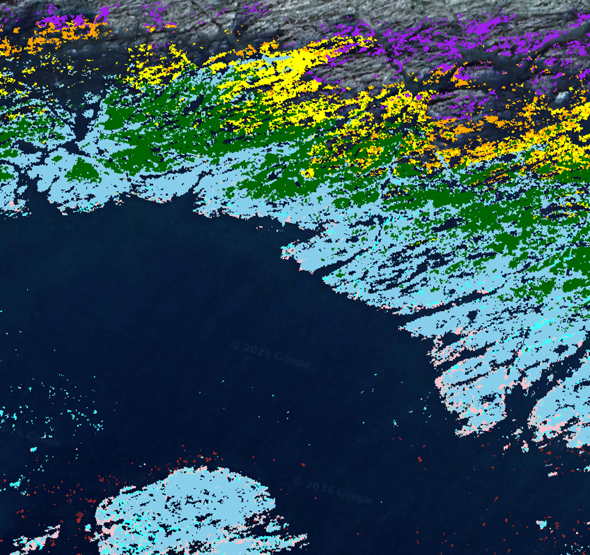
Multispectral sensors improve on this by measuring narrower, deliberately chosen bands, often including near-infrared or red-edge regions where vegetation can show strong diagnostic differences. Hyperspectral sensors go further again, recording many narrow contiguous bands and making it possible to detect more subtle peaks, troughs, slopes, and absorption features in the reflectance signal. For species-level ecological mapping, spectral width is often as important as the specific wavelength range being measured. The difficulty is that richer spectral data usually come with greater cost and complexity. Hyperspectral UAV survey can be powerful, but it is not yet an everyday ecological tool. Sensors are expensive, surveys require careful calibration, workflows are technically demanding, and the resulting datasets can be large and difficult to process. For research projects or high-value applications, the capability is valuable. For routine monitoring, invasive species management, woodland assessment, or restoration tracking, the practical barriers can be significant.
The Machine Learning Challenge
The state of the art is therefore not simply “better drones” or “more AI”. It is the development of workflows that combine UAV imagery, calibration, field data, and classification methods in a way that is both ecologically meaningful and operationally realistic.
Machine learning has an important role in this. Object-based methods can classify vegetation using not only pixel values, but also patch shape, texture, size, and spatial context. Classical machine learning approaches such as random forests and support vector machines remain useful, particularly where training datasets are limited or interpretability matters. Deep learning models can identify more complex visual and spatial patterns, especially when large labelled datasets are available.But ecological mapping is a difficult test for these methods. A model that performs well in a uniform agricultural field or on isolated tree crowns may struggle in a species-rich wetland, a riparian corridor, a plantation edge, or a mixed understory. Boundaries are often gradual rather than sharp. Species occur in mixtures rather than pure stands. The same species may present differently across a site. A model trained in one season, region, sensor setup, or vegetation structure may not transfer cleanly to another.
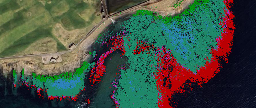
This is more than a technical inconvenience, because the patterns that are easiest to map are not always the patterns that matter most. A large, dense stand of an invasive plant may be relatively straightforward to identify once it is visible in the field or from imagery. The greater challenge is often at the margins: scattered individuals, diffuse patches, or early-stage incursions within mixed vegetation. These are precisely the cases where better spatial information can be most useful, because it can narrow the search area, prioritise field checks, and support intervention while the problem is still localised.
From Classification to Ecological Decisions
The same principle applies in woodland and restoration settings. Broad cover or apparent greenness can be mapped relatively easily, but many ecological decisions depend on composition, structure, and whether change is moving in the desired direction. In these settings, the value of UAV mapping lies in improving spatial representation. It can turn field observations from isolated points, quadrats, or transects into mapped hypotheses across a whole site. It can show where composition appears consistent, where it changes, where uncertainty is high, and where field validation should be targeted. The result is not a replacement for ecological expertise, but a better spatial framework for applying it.
That distinction is important. The useful output of UAV mapping is not a technically impressive classification map for its own sake. It is a map that changes what can be done: a more targeted invasive species survey, a more spatially explicit restoration assessment, a better understanding of woodland composition, or a clearer picture of where ecological change is occurring across a site.
Making Fine-Scale Mapping Practical
This is the space we are working in at Spectral Ecology. Our interest is in making fine-scale ecological mapping more practical, particularly where full hyperspectral survey is too expensive or complex for routine use. Rather than treating drone imagery as a photograph to be interpreted visually, we are developing workflows that extract more ecological information from practical RGB and multispectral sensors.
One route is hybrid classification. The first part of the workflow uses object-based analysis to describe vegetation structure and spatial context: the shape of patches, canopy texture, adjacency, and the relationship between neighbouring vegetation objects. The second part uses spectral information, supported by field calibration data, to improve discrimination between species or vegetation types that may appear visually similar. The aim is not to claim that low-cost sensors become true hyperspectral instruments. They do not. Rather, the aim is to model additional spectral features from calibrated RGB and multispectral data, and to use those features alongside structure and context. In practical terms, this may help bridge the gap between affordable UAV surveys and the richer spectral information usually associated with more specialist systems.
This matters because accessibility is part of the technical challenge. If fine-scale ecological mapping depends entirely on expensive sensors, specialist workflows, and large data-processing overheads, it will remain limited to a relatively small number of projects. The opportunity is to bring some of the advantages of higher-dimensional spectral analysis into workflows that are realistic for routine ecological monitoring, land management, and restoration assessment.
Useful Maps, Not Just Better Images
None of this removes the practical constraints. Whether flying a lighter setup or managing the heavier multispectral payloads of a larger airframe, UAV surveys are sensitive to weather, permissions, flight planning, illumination, sensor calibration, and data handling. Classification models are only as useful as their training data and validation design. Seasonal timing can determine whether a species is detectable at all, and a model that works well on one site may not transfer cleanly to another. These limitations are not peripheral; they determine whether a remote-sensing workflow produces ecological evidence or simply a convincing-looking map.
But the direction of travel is clear. Ecological mapping is moving toward a layered approach: field survey for biological resolution, satellites for landscape context, UAVs for fine-scale spatial coverage, and machine learning to connect observations across space. The promise of UAVs is not that they make ecology automatic. It is that they help overcome the long-standing trade-off between detail and extent.
If that trade-off can be reduced, ecological mapping becomes more than a set of sampled observations or broad habitat categories. It becomes a way to represent complex living systems at scales relevant to management. That is where UAVs have the potential to change the field: not simply by seeing from above, but by helping us map ecological detail continuously, repeatably, and in forms that can guide decisions on the ground.


Spectral Ecology Limited - Registered in England and Wales: 16386647 VAT Number: 496380548 Email: tom.fairchild@spectralecology.com © Spectral Ecology limited (2026)